Sunday 5 February 2017

Bruce Trail Hike 10 - (6 km)

(222 km of 894 km) 25% completed

It was a frigid -9 degrees and fresh snow covered the trail.  We were lucky to be joined by a special furry friend but also suffered an unfortunate event which caused us to cut this hike short of our 20 km goal.


Our friend seemed to really enjoy hiking.


Here she is showing us the way.  The only tacks on the trail were animal tracks.


"I think I saw something over there!"


Sometimes you have to cross streams.


Look at that smile.  She's so cute!


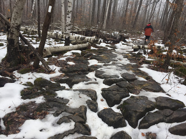
Friends in the distance.


The fields were so windy.  Sometimes we had to traverse through a foot of snow.


Taking a break to dust off snow.


This this brings us to the unfortunate event.   Coming down the rocks in the picture below, my friend planted her foot, took a step down but didn't realize she stepped on solid ice.  Her foot was planted so well, it stayed in the same spot while the rest her fell down.  Her knee bent in a way knees aren't supposed to bend.


Thankfully, we were only about 300 meters from the nearest road.  Due to a couple steep hills and rocks to climb, it still took us a very painful hour to reach the road.  I started running back for our car which was parked about 5 kilometers away.  Luckily, after about about 2 km and four people who drove by ignoring my plea for help, someone finally stopped and drove me back to my car.

I raced back to my friend and off the hospital we went.

She's in a soft cast and in a lot of pain so the BT Hike is delayed until further notice.

Wishing her a speedy recovery!

Saturday 21 January 2017

Bruce Trail Hike 9 - (16 km)


(216 km of 894 km)

After a bit of a break, we decided to re-start with a moderate 16km hike.


There is really something majestic about hiking in the snow.  


There was also a heavy fog which brought an eerie beauty to the trail.


Unfortunately, my friend had another little slip around this area.  It was pretty muddy and slippery in some sections.  That's fall number four, but who's counting. ;)

\


And this is my favorite picture of the hike.


Tuesday 3 January 2017

My Hiking Plans

Happy New Year!  Due to the weather and the busy holiday season, I'm not getting much hiking done so I thought I'd make a list of hikes I would love to do.  I'll start with the ones in Canada:

End-to-End Bruce Trail
Location: Ontario, Canada
Distance: 900 km
Time: 20 days

End-to-End Ganaraska Trail
Location: Ontario, Canada
Distance: 500 km
Time: 10 days

East Coast Trail
Location: Newfoundland, Canada
Distance: 500 km
Time: 12 days

La Cloche Silhouette Trail
Location: Ontario, Canada
Distance: 100 km
Time: 6 days

West Coast Trail
Location: British Columbia, Canada
Distance: 75 km
Time: 6 days

Sunshine Coast Trail
Location: British Columbia, Canada
Distance: 150 km
Time: 8 days

Fundy Footpath
Location: New Brunswick
Distance: 82 km (in and out)
Time: 7 days


Hikes in the USA:

1.) Pacific Crest Trail
Location: California, Oregon, and Washington, United States
Distance: 4,270 km
Time: 6-7 months

2.) Continental Divide Trail
Location: Colorado, New Mexico, Idaho, Montana
Distance: 4,270 km
Time: 7-8 months

3.) Appalachian Trail
Location: Georgia to Maine, United States
Distance: 3,515 km
Time: 5-7 months


Note: Completing all three hikes above is known as the Triple Crown.  The total length of the three trails is about 12,700 km; vertical gain is more than 1,000,000 feet, a total of 22 states are visited. Only a few hundred people in the world have completed all three.  I'll most likely start with #3.


Grand Canyon Rim-to-Rim Hike
Location: Arizona, United States
Distance: 70 km
Time: 4-6 days


Yosemite Grand Traverse
Location: California, United States
Distance: 100 km
Time: 6-7 days


Sierra High Route
Location: California, United States
Distance: 315 km
Time: Around 13 days


International Hikes:

Camino Trail
Location: Spain
Distance: 800 km
Time: 20 days

Kilimanjaro
Location: Tanzania, Africa
Distance: 56 km
Time: 7+ days

Everest Base Camp Trek
Location: Nepal
Distance: 115 km
Time: 16 days

Tour du Mont Blanc
Location: France, Italy, Switzerland
Distance: 170 km
Time: Around 10 days

Inca Trail to Machu Picchu
Location: Urubumba, Peru
Distance: 50km
Time: 4 days


Sunday 27 November 2016

Bruce Trail Hike 8 - (27 km)


(200 km of 894 km)


Today we reached a 200 km milestone.


This little guy wanted to come with us.


I really liked this bridge.  I wish I had a picture on it....


If anyone is looking to buy a Side Trail, feel free to call this number.


Our first break. Some nice rocky terrain.


I was excited to do a little bit of climbing.


Trees as far as the eye could see.


This was a fun little path.  The sign in the upper left means right turn ahead.


This was a fairly challenging downhill section.  The rocks were very slippery.  Unfortunately, it was around here where my friend took her third tumble on the trail.  To me it looked like a serious one, as she appeared to hit her knee hard on a rock, but she bounced up like nothing happened and kept going.


We met a handsome German Sheppard on the trail.


Lunch time, or should I say nap time.


Found a nice perch to eat my lunch.


We found a cave.  Should we explore it, of course we should!


This cliff was the highlight of the trip.


Oh, it's Mayhem!


Came across this structure in the middle of the woods and have no idea what it is.  If anyone knows, please comment below letting me know.


Monday 7 November 2016

Bruce Trail Hike 7 - (15 km)


(173 km of 894 km)

After a longer hike the day before, we decided to only do 15 km.  This hike had a fun little section called Mount Nemo.  The rocks were challenging and there were some little caves to explore.  Unfortunately, I saw another person take a tumble.  She had a prosthetic leg.  I thought it was inspirational and impressive to see her on the mountain.  I asked her if she was okay and she said yes.


Unfortunately, this hike has 6 km of road.  It seems as though someone bought a lot of property and wouldn't allow hikers on it, so the trail had to be rerouted.


Just in case someone watching likes horses...


Mount Nemo made the walk on the road worth it, but this place was crawling with people.  I couldn't believe how crowded it was.  While it took away from some of the solitude, I was glad to see people getting into hiking, except for the smokers.  I wish the people who smoke on the trail would have stayed home.


Are we going to go explore the caves?  Of course we are!


Summit of Mount Nemo.


Here is our route.  The 15 km took us 4 hours and 16 minutes, mostly because of sight seeing at Mount Nemo.


Below is the actual Bruce Trail map.  My GPS (a free app on iPhone 6 called Runkeeper) was fairly accurate.